Site Inventory and Analysis
An introduction to the site analysis process in garden design
Site Inventory vs. Site Analysis vs. Base Plan
SITE INVENTORY
A site inventory is simply the physical items that are currently on site.
Site Analysis
A site analysis is an analysis of how the site interacts with things like people, vehicles, the weather, sounds and more. For an assignment it is usually a legible drawing that uses symbols to convey the interactions on the site to convey your understanding to your teacher. However, in a normal work process it is likely a drawing on a scrap of transparent paper that never leaves your office.
Base Plan
A base plan is a plan page that covers the items that will be on every plan that you create and no more. Historically before CAD it was critical you did not include anything that was not going on every page so that you did not need to go back to the print shop or sit there scratching lines off with razor blades when you decided something was going to be removed off the site. Now on CAD we generally use layering or class strategies that can be made retrospectively so it is not as critical to get this right from the start.
What is a Site Analysis?
To undertake a design we need to understand and document the site. A site analysis is the act of surveying a site, taking an inventory of what you find and then analysing the data.
Conducting a Site Survey / Inventory
What physical items do we need to locate?
Services
Gas
Electricity
Water
Sewerage
Phone
Internet
Trams and trains
Structures
Buildings
Fences
Sheds
Water tanks
Elements to be removed
Arbors
Retaining Walls
Raised Beds
Vegetation
Weeds
Existing trees
Significant specimens
Topography
Spot levels
Contours
Analysis
Depending on the scope of the project the windows and door locations and views can be quite important. It can be necessary to have these recorded so that you can utilise the views, lines of site, movement, and desire lines that they determine.
Borrowed landscape
The borrowed landscape is what you can see from your site that doesn’t fall within its boundaries. If you are on the beach-side this could be a view out to the water and the cliffs. If you are in the city, it could be a view to a half-finished wall painted bright red and someone’s bedroom.
Movement
How does the site currently get used? Where do people move to and from? Think about vehicular movement as well
Node Points
Points where movement splits into two or more directions
Views
What views around the site are good and what would you prefer not to see?
Sun path
What is the path of the sun over the year? How does it change?
Sunny and Shady areas
Where are shadows cast throughout the days?
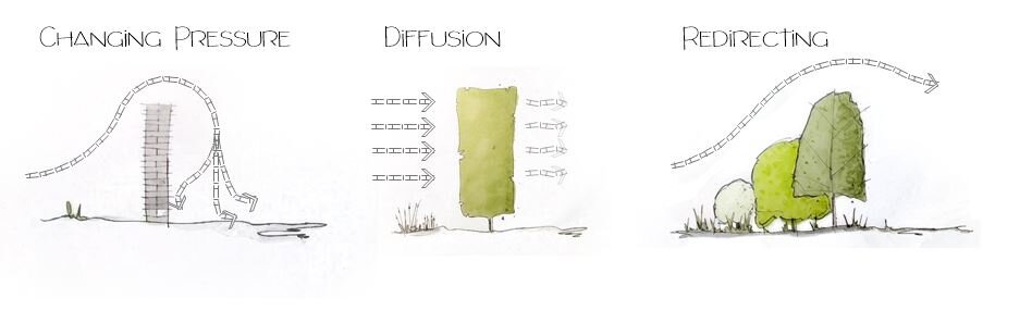
Wind
Where are the predominant winds coming from? What are the windiest areas? Are there protected areas?
Zoning
Are there zones throughout the site where certain functions are undertaken?
Noise
Is there noise pollution across the site? Are there noises which add to the ambience?
Soil
Testing results of soil
Microclimates
What are the attributes of the spaces that differ from the wider climate of the area?
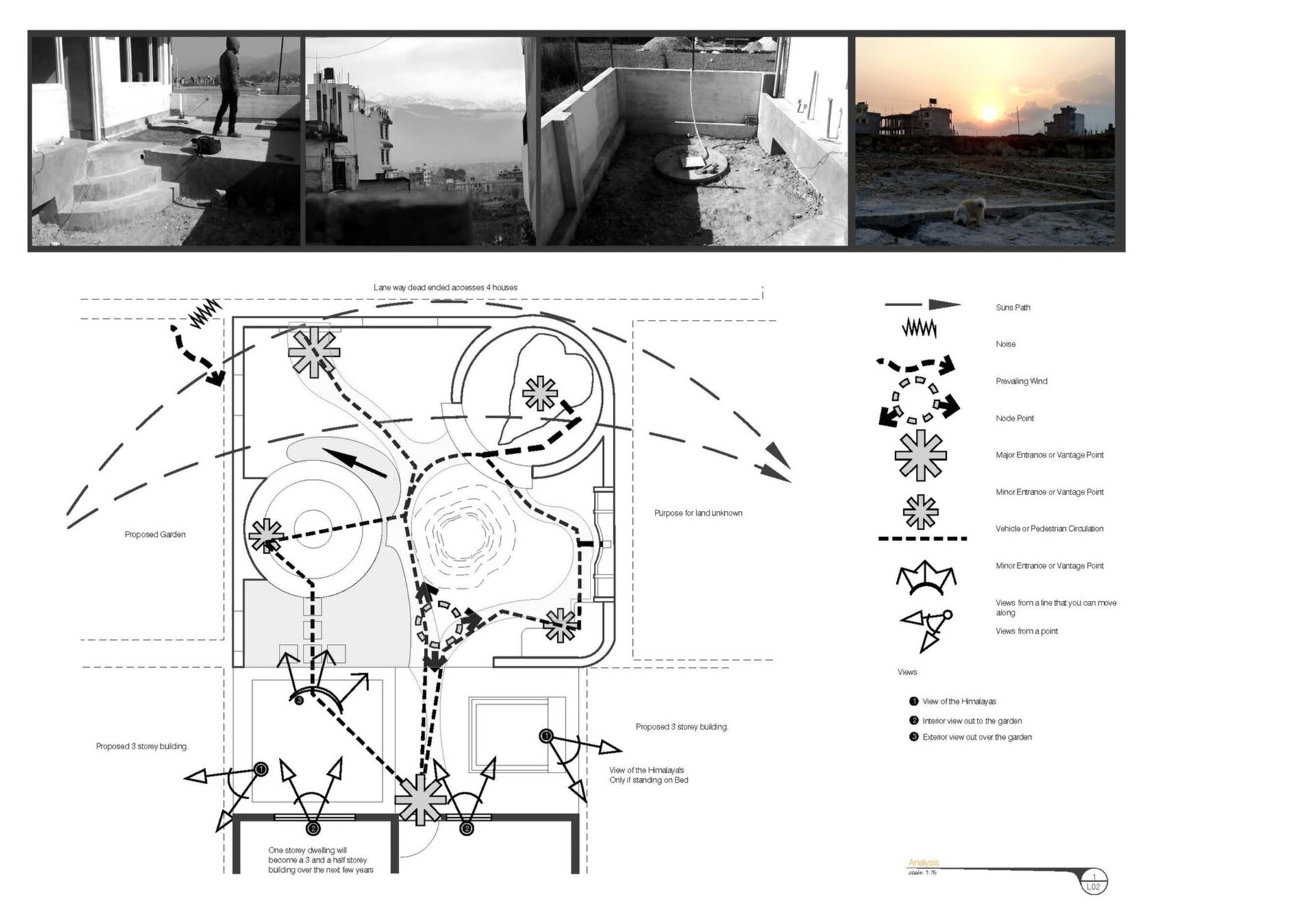
Example of a drawing capturing the way in which a site can be used, views, noises, sun path and wind
Sustainability Considerations
Water
What is the sites ability to capture water?
Do the site contours give opportunities for water capture?
What roof surface area is available for capturing water?
How is this affected by temperature levels?
Is rainfall causing erosion or sediment pooling?
Is the site susceptible to flooding?
Is there available groundwater?
Soil
What is the soil quality and how does it change over the site?
Is there any contamination?
Is it suitable for growing food crops?
Vegetation
Are there weed species that pose a risk to the surrounding environment?
Energy
Are there opportunities for renewable energy interventions?
Are there opportunities for solar passive design?
Materials
Are there materials that would be hazardous to health such as asbestos on the site?
Measurement
Measuring up a site is not an easy task. There are a few methods we can use for measuring the spacial layout of a site
Traverse Line
In this method we run a long tape measure in a line and then we measure off that tape measure to the elements on the site.

Traverse Line Example
Triangulation
Triangulation is a method to find the exact location of an object relative to two other objects.
In triangulation we use to known points A and B. You should use objects that won’t be removed and are easily accessible. A good example could be either end of a wall. From point A and point B you should now measure to point C which is the object you wish to locate. Now when you get back to the office you will be able to use a compass and draw a circle of the radius from your measurement A to C starting at Point A. Then do the same for your measurement B to C starting at point B. Where the two circles overlap will be where object C is located.

Triangulation Example
Session Outline
What is a site analysis?
Conducting the site survey
Measurement
Levels
Presentations
Activities
Definitions
Desire lines / path - Often the shortest path between two elements. It could also be the path that someone would take if there wasn’t something blocking their way.
Borrow Landscape - The borrowed landscape is what you can see from your site that doesn’t fall within it’s boundaries. If you are on the beach-side this could be a view our to the water and the cliffs. If you are in the city it could be a view to a half finished wall painted bright red and someones bedroom.
Levels
This is often the hardest part for people new to the industry to understand and measure. It is also an area where very costly mistakes can be made. You can have a site survey conducted on your behalf by professionals to avoid this.
SWOT Analysis
Analysing the sites Strengths, Weaknesses, Opportunities and Threats will help you set realistic objectives for you project. See examples below.
Strengths
Soil has pH that is suitable to a large variety of plants both exotic and indigenous
Surrounding building limits wind within the site
Opportunities
Boggy Depression in back corner could be used as an ephemeral water feature
Weaknesses
Boggy Depression in back corner with compacted anaerobic soil
No vegetation on south boundary exposes building
Threats
Threat to privacy of entertaining space from overlooking building
Lack of airflow could lead to fungal infections on susceptible plants